Abstract
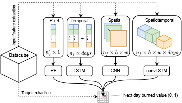
Wildfire forecasting is of paramount importance for disaster risk reduction and environmental sustainability. We approach daily fire danger prediction as a machine learning task, using historical Earth observation data from the last decade to predict next-day’s fire danger. To that end, we collect, pre-process and harmonize an open-access datacube, featuring a set of covariates that jointly affect the fire occurrence and spread, such as weather conditions, satellite-derived products, topography features and variables related to human activity. We implement a variety of Deep Learning (DL) models to capture the spatial, temporal or spatio-temporal context and compare them against a Random Forest (RF) baseline. We find that either spatial or temporal context is enough to surpass the RF, while a ConvLSTM that exploits the spatio-temporal context performs best with a test Area Under the Receiver Operating Characteristic of 0.926. Our DL-based proof-of-concept provides national-scale daily fire danger maps at a much higher spatial resolution than existing operational solutions.
Add the full text or supplementary notes for the publication here using Markdown formatting.